Beautiful spring Mother’s Day weekend before a touch of summer
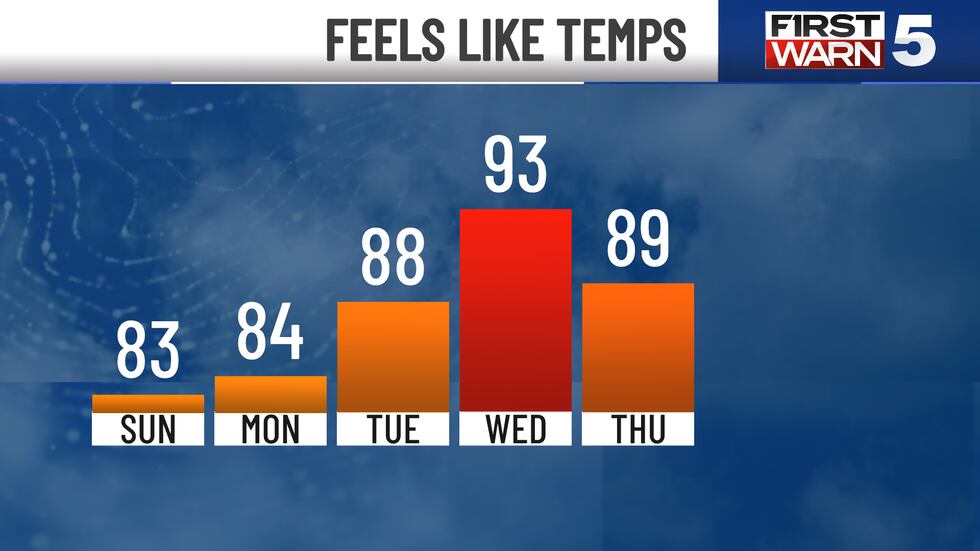
KANSAS CITY, Mo. (KCTV) - Our Sunday forecast is for the moms! We are expecting to go from the mid 50s in the morning, to the lower 80s in the afternoon. Expect a good deal of sunshine and a light breeze out of the southeast. There might be a few ing afternoon clouds, but all in all it’s a great day to be outdoors. Another nice touch is the lower humidity levels we have in place, for now. Just a reminder, the sun’s rays are getting very strong this time of the year, so that sunscreen!
Lower 80s stick in place for Monday. We have a very slim chance at a random shower, especially into central Missouri. Our humidity levels start to climb on Tuesday, but so do our temperatures. We are expecting mid 80s Tuesday and upper 80s Wednesday. Some spots could very well push 90 degrees. With moderate humidity, our heat index values could be a few degrees warmer in the lower 90s. With warm afternoons and an uptick in moisture, we can’t rule out a random bubble up shower or thunderstorm, but most of us look to stay dry this next week,
Our hottest day will be Wednesday in the upper 80s, followed by mid 80s on Thursday. There is a cold front that starts to invade the region later in the day Thursday. At this point, our computer model guidance does not indicate any thunderstorms forming, but we are a little skeptical. We are keeping a 30% confidence for a few storms later in the day Thursday and will have a better idea of what the atmosphere will do as we get a bit closer.
We ditch the hotter temperatures for more comfortable conditions next Friday and Saturday, back to the lower 80s. It’s a warm stretch! Our normal highs this time of the year are around 73 degrees.
To get the latest weather updates sent to your phone, the KCTV5 Weather app here.
Copyright 2025 KCTV. All rights reserved.